FAA Announcing No-Drone Zones
In more recent news, the Federal Aviation Administration has released some new flight rules that are, at the very least, very restrictive for certain areas. While no-drone zones aren’t anything new, we have some new areas on the updated list.
A map data of restricting residential drones has been pushed for the purpose of keeping them out of military bases and airspace, but that’s only the tip of the iceberg. In short, the list has been updated as a result of a number of very close calls regarding people piloting their drones.
In fact, the number of close calls and “your drone should not be here” incidents have doubled within the last six months alone. This is, of course, compared to the same amount of time as last year, but now the FAA is really starting to crack down.
The New No-Fly Zones and Map Data
On the 11th of this month, the FAA stated that the first set of map data will be released for the purpose of ensuring private UAS operations being able to safely navigating their drones around all commercial airports, so no more incidents can occur.
“Facility maps” are also coming. These maps specifically will show the altitudes and the areas within range of airports that drones can operate in. This will help pilots to further comply with their Part 107 airspace authorization rules. These rules are almost a year old.
Starting on April 14th, drones cannot be operated within at least 400 feet from any military facility’s boundaries in accordance with the new restrictions for military bases, which was also pointed out by the FAA.
The FAA and the Defense Department announced on the 7th of this month that new restrictions across the US regarding over 133 military bases are coming.
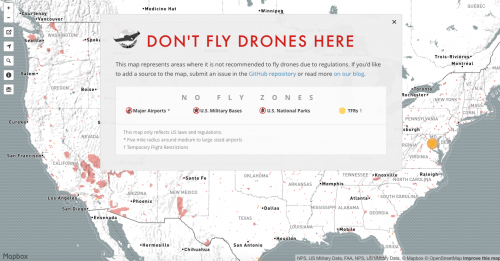
Their interactive map details these no-drone zones to the letter.
These restrictions have been put in place because of, again, pilots violating the boundaries. Now, however, any residential pilot caught doing so anymore will receive criminal charges and civil penalties as a result.
What’s more, the FAA is now considering adding a lot more to their maps based on requests for strict flight restrictions regarding drones from intelligence agencies and federal security.
This is based on the process that was mandated further by the FAA Extension, Safety, and Security Act that came into effect during 2016.
The Release Date for All of the Maps
The FAA is releasing the first set of maps on April 27th of this year. The first release will contain up to 200 maps that have subsequent information to ensure that the map database can be understood thoroughly by all pilots.
The maps will be synced to the existing 56-day aeronautical chart schedule for further production by the FAA.
The Bigger Picture to These Maps
Because there are a lot of residential drone pilots who have been drastically breaking the rules, flying where they shouldn’t be, and causing a number of issues for a lot of people, the FAA has basically had no choice but to implement these restrictions and maps.
In accordance with legal UAS airspace, the FAA is hoping that these maps will be used properly and not just as a general guideline. They are also hoping that, by completing the Part 107 operations application, drone users will comply with legal altitudes and specified locations for flying.
These maps will be introduced as “information only” pieces of information, which are not authorizing flights in any way. This means that using them does not guarantee any solid authorization applications and that they may not even be approved for residential drone users.
The Importance of Not Abusing Airspace
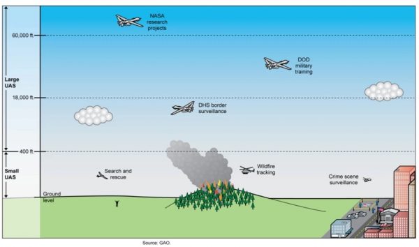
Examples of Current Uses for UAS and their Altitudes of Operation
For those who are upset by these incredibly strict restrictions regarding airspace and where you can and cannot fly, remember it’s for the fun and safety of everyone. Unfortunately, a lot of residential drone pilots couldn’t seem to comply with not flying their drone into the airport, so this is what we’re left to face with.
The FAA has stated that they will be released periodically throughout 2017, so happy flying!

Kennedy Martinez
kennedy@dronethusiast.comKennedy Martinez is a resident writer who joined Dronethusiast at the beginning of 2019. She has years of experience reviewing drones and other tech products. When it comes to flying drones, Kennedy loves the ability to create artistic videos from a unique point of view. Kennedy enjoys researching new drones and other exciting products that are available to consumers which is why she is committed to creating the best buyer's guides for our readers.


