University of Colorado Using Drones to Measure Soil Moisture

The University of Colorado Boulder has a research team that is developing technology to help farmers who want to gain a better look into their water management systems. Poised to save farmers money and time, the University of Colorado Boulder program is sending drones to a test farm in Yuma. These drones are a part of Project Drought that is pairing research with ongoing measurements from NASA’s Soil Moisture Active Passive Satellite system and the data that is recorded via sensors at the Irrigation Research and Demonstration farm. Researchers are hoping to provide a unified system that will allow farmers to gather data regarding their soil moisture and to prepare a more drought-friendly irrigation system.
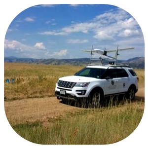
Drones from Boulder’s Black Swift Technologies are heading over to the Yuma Irrigation Research and Demonstration farm to gather soil moisture data that is shared with five different drought research initiatives. These research groups include Colorado University’s Integrated Remote and In Situ sensing project headed by professor Brian Argrow who is also working with Colorado University’s Ann and H.J. Smead Aerospace Engineering Sciences Department. The combination of the research is designed to provide helpful answers to solve important global or national problems with soil moisture and crop growth.
The issue that has been slowing the research involves the flight systems of the drone aircraft. Those involved are working to ensure that the sensors and the aircraft work together while the flight systems are engaged, making precise measurements much less difficult. A fixed-wing SuperSwift drone designed by Black Swift Technologies offers a removable nose cone that will fly all of the test over the Yuma farm. This drone’s nose cone is equipped with a specialized sensor developed by Al Gasiewski’s team at Colorado University’s Electrical, Computer and Energy Engineering department and the Center for Environmental Technology.
Launched in 2015, NASA’s Soil Moisture Active Passive Satellite system had a primary radar failure, but the passive radiometer still produces surface maps with each pixel representing an area of 225 miles. Creating country drought scale measurements provides farmers with the information that they need to determine crop rotation and planting schedules but the data is not enough to create specialized planning for crop determination. The combination of the fixed sensors in the soil at the Yuma Irrigation Research and Demonstration farm and the NASA satellite images means that the influx of the drone technology will make mapping extremely precise.
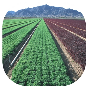
Users of the drone technology to measure soil moisture are hoping that this service will provide farmers with the immediate information that they require to ensure the best crop production and harvest. Offering the drone technology as a service to fly over an entire crop area to assess portions of the soil that require a change in irrigation. Pinpointing dry areas and areas that are overly irrigated means saving dollars when it comes to the bottom line of food production.
Colorado University has thrown down the gauntlet when it comes to the use of drones in the measurement of soil moisture. Claiming to have flown more drone more research drones in more areas of the world than any other university, students at the university are providing useful research using the state-of-the-art in unmanned aircraft. Since the embedded sensors, the sensors placed in the removable nose cones on the drones and the satellite imagery are required to work togetherscientists and engineers are teaming up with the students to produce optimum results.
Black Swift Technology’s fixed-wing drones offer less disruption of the sensors than other drone styles, making this drone the perfect choice for carrying sensitive data equipment. Water management is a huge concern in areas of the country that are prone to drought and land owners express frustration when it comes to accurately determining which areas of land require increased irrigation during specific growing seasons. The use of the drones means measurements are flexible and can be offered at any time of the year, even at short notice or in areas where in-situ sensors are not present. Less expensive than implanted sensors and requiring very little energy to run, the Black Swift Technolgy drones are seen as a great option for even smaller farms that require more hands-on irrigation research.
Project Drought is a timely addition to the drone research foundation that includes drones used to provide information regarding siezmic disruptions, natural disasters and even weather patterns. World irrigation issues affect the entire planet making food production difficult in arid areas that are not offered the option of irrigation research. The Black Swift Technology drones create a platform for research that allows large areas of farmland to be surveyed with little manpower and at a cost that makes this type of research accessible to even the smaller commercial farms. Other uses for the technology include mapping for land use, search for land slides and access to water runoff for reuse in irrigation systems. Precision irrigation mapping provides plenty of information that is required to set up farming in a system that suits each area.
Kennedy Martinez
kennedy@dronethusiast.comKennedy Martinez is a resident writer who joined Dronethusiast at the beginning of 2019. She has years of experience reviewing drones and other tech products. When it comes to flying drones, Kennedy loves the ability to create artistic videos from a unique point of view. Kennedy enjoys researching new drones and other exciting products that are available to consumers which is why she is committed to creating the best buyer's guides for our readers.


