The Drone That Uses its Camera to Fly, No GPS Needed
Drones have been evolving quickly with more smart, innovative features At the University of Toronto’s Institute of Aerospace Studies (UTIAS), researchers have been perfecting a new drone technology by creating a drone that can fly on its own, no human pilot required.
The researchers have even more ambitious goals and are working to create a self-flying vehicle that can find its way home based solely on what its cameras can see, in case it can no longer locate itself with a GPS system.
University of Toronto researchers have been developing a drone that would be able to fly along a previously known route when faced with a range of location-related uncertainty, such as interference from tall urban buildings, hostile attempts at the remote control, or in the worst case, outright failure of the drone’s GSP hardware or the satellite network.
“The vehicle would fly with GPS, and then if GPS gets lost, the vehicles could fly back completely based on vision,” said assistant professor Angela Schoelig, who is overseeing the research as head of the school’s Dynamic Systems Lab, with professor Tim Barfoot of the Autonomous Space Robotics Lab.
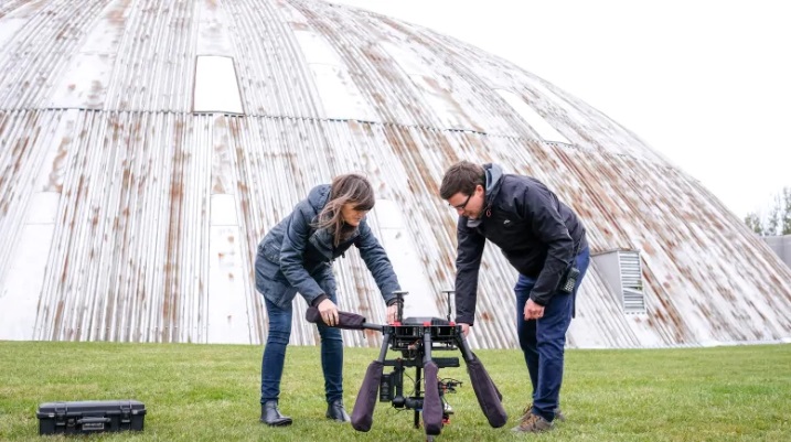
(Evan Mitsui/CBC News)
This research was first presented in a paper published in 2017. They believed they could take a technique called Visual Reach and Repeat (VTR), which had first been pioneered by Barfoot and his lab for use on ground-based robots, and adapt it for use in the air.
With VTR, the vehicle follows a pre-determined route – either under the manual control of a human operator or using GPS – and collects data along the way, noting landmarks and other unique features it sees below.
If the vehicle were to lose GPS connection when flying on its own, it would attempt to return home by following the path it was previously taught. In order to orient itself, the drone compares the visual input from its cameras to what it saw before the same way a person would likely look for a familiar storefront to guide them out of a sprawling shopping mall.
This would happen quickly and you’d never know the drone was using its cameras rather than the GPS to guide itself.
The UTIAS team’s most recent paper was published in the January issue of IEEE journal Robotics and Automation Letters and was led by postdoctoral fellow Micahel Warren, Ph.D. student Melissa Greef and masters student Bhavit Patel.
Last spring, the team spend a week collecting data at Defence Research and Development Canada’s (DRDC) Suffield Research Centre in southern Alberta. The results were encouraging: Warren said that during simulated GPS outages, their drone could reliably fly itself at about 10km/h at an altitude of 25 meters, an din calm winds as fast as 20km/h.
Challenges ahead include eliminating shadows from the drone’s visual input, which can confuse the image recognition algorithms. Another is handling seasonal change or teaching the drone to recognize locations over time for instance, after a snowfall.
The drone isn’t self-aware enough yet to understand when its GPS signals can’t e trusted, prompting the fallback to kick in.
“In the next few months, we want to make it even more reliable and push the limits,” said Schoellig. For example, flying at lower altitudes where the ground moves too quickly for the current design to keep up, while potentially augmenting the drone’s own imagery with previously gathered satellite imagery.”
Shoellig’s lab aren’t the only people furthering drone’s capabilities and testing their reliability. Companies from tech giants to startups and traditional aerospace companies have all been working on drones that can fly farther, faster, and take on more responsibilities.
The possibilities of what drones can do are limitless. The hope is that autonomous drones might be used to conduct detailed surveillance, provide temporary connectivity and communications, ferry passengers or even replace jobs such as window washing and building maintenance.
Package delivery is one of the most anticipated applications to be added to the list of drone responsibilities. However, one of the most critical tests is proving that drones can make deliveries safely and reliably in a wide range of conditions and environments – without disruption.
Amazon and Google’s parent company, Alphabet, are perhaps the highest-profile companies working to making drone-assisted deliveries a reality.
Many are working to make drones more technologically advanced and push them to the limit with their responsibilities. With the advancements from the team at UTIAS and other major tech companies, we could be seeing drones doing way more in the near future.
Kennedy Martinez
kennedy@dronethusiast.comKennedy Martinez is a resident writer who joined Dronethusiast at the beginning of 2019. She has years of experience reviewing drones and other tech products. When it comes to flying drones, Kennedy loves the ability to create artistic videos from a unique point of view. Kennedy enjoys researching new drones and other exciting products that are available to consumers which is why she is committed to creating the best buyer's guides for our readers.


Well if this automated technology reaches mainstream mapping and agricultural drones and probably even photography then maybe it wouldn’t be worth it for me to even bother getting my 107a pilot’s license sounds like I might be better off just going to automated drone school.