Drone Captures Kilauea Eruption – Evacuations in Hawaii Taking Place
After a severe 6.9 magnitude earthquake on Hawaii’s Big Island, the eruption of the Kilauea volcano has more than 10,000 fleeing, forcing them to evacuate from their homes.
Hawaii’s Big Island has been shaken to the core, due to the biggest earthquake since 1975 on the volcanic island chain. As of Monday morning, the Civil Defense of Hawaii has reported that as many as 31 structures, some residential, have been destroyed by the spewing, flowing lava.
According to the US Geological Survey, the earthquake initially began around 12:30 pm local time, 2232 GMT, centering around the south flank of the volcano in Kilauea. The outbreak of the lava began after hundreds of small tremors and earthquakes in the days following said outbreak followed the total collapse of the crater floor on the volcanic cone of Puu Oo.
First erupting last Thursday, another 5.7-magnitude tremor further hit the island early last Friday. Though a number of days have passed, authorities are expecting more seismic activity and further tremors due to the magma underground.
Hawaii’s Fire Department has continued to order evacuations due to the high levels of sulfur dioxide gas. At this time of writing, evacuations are continuing within the Leilani estates, which is a residential area of the island.
The gas is extremely dangerous for anyone to breathe in. As it’s being emitted into the air and the overall atmosphere, acid rain has been created. Authorities continue to warn those being evacuated that as soon as they are safe and clear of the area, that they must wash themselves off due to the fact that it’s creating skin irritation when direct contact occurs.
Mount Kilauea has been erupting since last Thursday, which has resulted in the National Guard bringing in military reservists to aid in the evacuation of residents in the local area. At this time of writing, though the destruction is great, there are no injuries reported thus far.
Unfortunately, one of the major factors in the spread of the lava damage, is the number of increasing fissures. The land is continuing to split open, exposing addition lava that lay just underneath. This is creating a lot more areas where lava has continued to spew from beneath the surface of the earth.
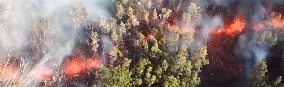
Though the FAA have issued a Temporary Flight Restriction, or TFR, for the entire area, one drone user took to the skies to capture the volcano’s eruption, the spewing lava, and all that came with it in the residential area.
The footage, which is from an Inspire 2 by DJI, shows the lava’s activity through a nearby, local forest. Bubbling lava can be seen coming from cracks in the street in both the Leilani Estates and the Lanipuna Gardens neighborhood, which is all but empty of residents.
Governor Ige has activated Hawaii’s National Guard troops, as we mentioned earlier, and has let residents know that official warnings must be kept in mind. During his declaration for the emergency, he mentioned that the current flow of lava is much like the Kapoho eruption that took place in 1960.
Jeremiah Osuna, who is responsible for the drone footage, noted that everyone should be prepared, which is why he took and uploaded the footage from his Inspire 2.

Kennedy Martinez
kennedy@dronethusiast.comKennedy Martinez is a resident writer who joined Dronethusiast at the beginning of 2019. She has years of experience reviewing drones and other tech products. When it comes to flying drones, Kennedy loves the ability to create artistic videos from a unique point of view. Kennedy enjoys researching new drones and other exciting products that are available to consumers which is why she is committed to creating the best buyer's guides for our readers.


